ELF Trails and Research

  • About ELF
    • Who We Are/ Mission
    • Our History
    • Donate
  • What We Do
    • Campaigns
    • Legal Cases
  • Media
    • Articles
    • Letters
    • Press Releases
    • Podcasts
    • YouTube
    • Vimeo
  • Research Reports
    • 2025
    • 2023
    • 2021
    • 2018
    • 2017
    • 2015
    • 2014
    • 2012
    • 1990s
  • ELF Reports
    • 2026
    • 2025
    • 2024
    • 2023
    • 2022
    • 2021
    • 2020
    • 2019
  • Resources
    • BCTS 5 Year Plan 2023 – 2027 Directory
    • BCTS 5 Year Plan 2023 – 2027 – Mount Elphinstone
    • BCTS – Updates
    • SCCF Operating Plan
      • Block List
      • Block List – Public Feedback
      • Operations Map
    • Engagement Plan for South Elphinstone – 2022
    • Assessment of the Burnett Creek Tributary Landslide
    • Elphinstone Medicinal Plants
    • Forest Related Research
    • Maps
      • SCCF Age Class claims vs reality
      • BC Gov Old Growth Maps
      • Sunshine Coast Forest District
      • Sunshine Coast Landscape Unit – OGMA – BioGeoClimatic Zones
      • BEO Zone Maps – biogeoclimate forest zones on the Sunshine Coast.
      • Sunshine Coast-remaining natural forests
      • OGMAs in Howe and Chapman Landscape Units
      • Google Earth – Maps – Dakota Bowl Watershed
      • Google Earth – Maps – Dakota RidgeThe following Google Earth image shows the close proximatey of the Dakota Ridge Recreation Area to the proposed TSL:A84612 cutblocks of the Ministry of Forestry. For the many reasons layed out within the website the Dakota Ridge Ancient Forest need to be saved to become part of a protected area and enjoyed by all.
      • Google Earth – Maps – Wilson Creek Forest (EW002)Wilson Creek Forest is situated on the lower slopes of Mt Elphinstone a short 10 minute drive from the Hwy 101 intersection at Roberts Creek.  It sits directly above the Wilson Creek Plaza.  As these pictures show it is one of the few remaining intact forests close to an urban center. It is an Inter-Urban Forest never before logged. It contains many old-growth features, including beautiful stands of tall, old Coastal Douglas-firs. The Wilson Creek Forest is on the books of Sunshine Coast Community Forests (SCCF) to be logged.  A stay of execution was ordered until further studies are undertaken. Directly below this forest is an 2010 Island Timberlands clearcut, and above it are a series of BCTS blocks.  If this patch of forest was allowed to be logged, it would link up clear-cuts to the north and south, creating a massive logged out area.  The Wilson Creek Watershed has experienced 50-60% forest cover loss which should trigger a moratorium on all future logging.  Over logged watersheds are known to lead to wild fluctuations in water flow levels which leads to bank instability, increased sediment levels and because Wilson Creek is a salmon bearing stream it all adds up to a…
      • Google Earth – Maps – Mt Elphinstone AreaThis aerial view (provided by Google Maps) shows the extent of logging on the lower slopes of the Mt Elphinstone area, above the village of Roberts Creek.  The largest of the clearcuts is the infamous 160Ha (400 acre) CNI (Columbia National Investments) cutblock  on their private lands.  CNI was later charged on a fisheries violation for logging completely through a fish bearing stream.  The other cutblocks seen are BC Timber Sales clearcuts.  A proposed BCTS Block A87124 would connect up with the CNI clearcut on its southern boundary, adding to the total de-forested area.
      • Community Interface Zone – Closely Matches Park ExpansionCheck out the map link below in pdf form and see how closely the Ministry of Forests ‘Community Interface Zone’ in Roberts Creek matches our proposed Park Expansion. Regarding the proposed Elphinstone Park expansion it is interesting to note that the proposed expanded boundaries of the park match very closely an area above Roberts Creek identified on a Ministry of Forests map as a ‘Community Interface Zone’.  In other words an area where the Ministry of Forests has for some time recognized that there is an overlap of logging interests and Community Interests such as recreation, environmental protection, water source protection, etc.  Surely the Community and Environmental values far outweigh the short term value of clear cut logging in this Zone. Another reason in favour Elphinstone Park Expansion Proposal. Map Community Interface Zone  
      • Age Class Maps
      • Area Maps – 5 Year Logging Plans
      • Community Forest Logging Maps
      • shíshálh Nation swiya Map
    • Gibsons Integrated Stormwater Management Planning
    • LRUP (Local Resource Use Plan) – call for moratorium on BCTS cutblocks…Sunshine Coast residents are upset watching the 1,500Ha lower slopes of Mt. Elphinstone being logged out. Sure trees grow back, however I want to express that BC Timber Sales’ plan to turn this, high-value multi-use area, into a continuous series of tree farms is unacceptable based on several environmental and economic reasons. This area has a few isolated forest patches protected, i.e.: the 139Ha Elphinstone Prov. Park (along with some surrounding OGMAs) while logging of the last remaining intact forests continues. The 1,500Ha mountain slopes is used by a diverse set of stakeholders, but the area is being compromised by a lack of an integrated plan. This situation calls for a LRUP (Land Resource Unit Plan), so that increasing tensions can be resolved. After the popular TrailFest-Wagon Forest was logged, it became clear that the public is not being listened to. BCTS was approached to find 27Ha (the cutblock size) outside of the 1,500 lower slopes as a solution, however our voices went unanswered. The public (including 1st Nations) must be invited to roundtable meetings to discuss and resolve this land use management problem. Its essential to impose a moratorium on all future BCTS cutblocks planned within the 1,500Ha area…
    • Mount Elphinstone – History of Conflict  1983 Logging on Mt Elphinstone causes disastrous flooding in neighbouring residential area during heavy rains. 1985: B.C. Ministry of Forests ( MoF ) sets up a short-lived Elphinstone Local Resource Use Plan( LRUP ) process that excludes community involvement. MoF continues to issue logging permits on Mt. Elphinstone. 1990: MoF plans to spray herbicides in clearcuts within Mt. Elphinstone domestic watersheds. Local residents successfully blockade the attempt. 1991: MoF resurrects the Elphinstone LRUP process. MoF refuses to participate in public meetings. Community members form a Concerned Coast Residents group and submit a silviculture plan to the LRUP. MoF rejects their proposal and continuous to allow industrial logging on Mt. Elphinstone. 1992: Mof opens the LRUP process to local input and makes assurances “that nothing will happen” without the “sanction” of the LRUP committee. 1993: MoF advertises Mt. Elphinstone cut blocks and continues to allow road building and logging without LRUP committee report. 1993: MoF places arsenic-treated structures in Flume Creek, the source of water for more than thirty licensed water users in the Elphinstone area. 1994: Concerned Coast Residents, Elphinstone Electors, Roberts Creek Community Association and Forest Watch members re-state their concerns regarding clean water, biodiversity and sustainable jobs…
    • Overview of Community ForestAttribution: The Following overview is taken from the SCCA (Sunshine Coast Conservation Association) Introduction The Sechelt Community Forest is a logging company. It is licensed by the provincial government to log within certain mandated areas and required to meet a minimum annual cut. This business venture is owned by a single shareholder – the District of Sechelt. Although the District claims to maintain an “arms-length” relationship, we suspect that the purpose of this policy is to insulate the District of Sechelt from public pressure related to the community forest. A History of Public Concerns Ignored The SCCA is not categorically opposed to community forests, per se. We were the original proponents of community forestry in the Sunshine Coast Regional District, and so we were very interested when the District of Sechelt announced its intention to apply for a “probationary community forest agreement” in 2003. Unfortunately, it soon became obvious that the District’s application was entirely about opening up the Chapman/Gray drinking watershed (and other sensitive areas) to logging and that the District did not intend to genuinely consider the concerns of the community about this. Just about everyone imaginable (including the Sechelt Indian Band, the SCRD, the Town of Gibsons,…
    • Economic Value Ecosystems Provide[gallery link="file" columns="1"] Article: Vancouver Sun – October 28, 2010 David Susuki Foundation and Pacific Parklands Foundation – Report Examines the extent of the regions ‘natural capital’ – forests, fields, wetlands, watersheds and other ecosystems and estimates the economic values the ecosyetms provide.  The study found that the ecosystems with the highest values are wetlands($4,000 to $6,000 per hectare) and forest ($5,900 to $7,400 per hectare)per year…..  
    • Ancient Forests – the Canopy – EcosystemsTED Talks – Richard Preston on the giant trees http://www.ted.com/talks/richard_preston_on_the_giant_trees.html Science writer Richard Preston talks about some of the most enormous living beings on the planet, the giant trees of the US Pacific Northwest. Growing from a  tiny seed, they support vast ecosystems — and are still, largely, a mystery.  TEDTalks2008 – Filmed Feb2008 [hr] TED Talks – Nalini Nadkarni on conserving the canopy. http://www.ted.com/talks/nalini_nadkani_on_conserving_the_canopy.html A unique ecosystem of plants, birds and monkeys thrives in the treetops of the rainforest. Nalini Nadkarni explores these canopy worlds — and shares her findings with the world below, through dance, art and bold partnerships. TEDTalks2009 – Filmed Feb2009 [hr]
    • Suggested Reading-Books-PapersThe following are a suggested reading list of books, articles and papers on the forest and our environment.  Feel free to contribute.   Thanks. Reading List on Related Subjects – Rick O’Neal
    • Forest Recreation
      • Mountain Biking On The Sunshine Coast
    • Forest Bathing – Learn About the Health Benefits of Forests
    • FAQQ: What Forest Service Map areas do Roberts Creek, Gibsons, Mt Elphinstone and Dakota Ridge fall under? A: They are all considered as being a part of the Chapman & Howe Landscape Units. [hr] Q: How much of the Sunshine Coast forests (Timber Supply Area – TSA) are protected?  A: According to the MOF Public Discussion Paper – the Timber Supply Review that sets the AAC (annual allowable cut) only 2% of the whole area (which extends up into Desolation Sound) is set aside for parks and ecological reserves. Details: Sunshine Coast TSA core area= 1,560,426 hectares 2% of this is parks and ecological reserves (30,481 hectares) 4% of this is private land (62,129 hectares) 67% of this is non-forest (1,041,953 hectares) The remaining 27% is productive forest (425,863 hectares) Of this productive forest, approximately half or 222,894 hectares makes up the timber harvesting land base. Source: Ministry of Forests (MOF) , Lands and Natural Resource Operations, Sunshine Coast District
    • Letters to the Editor – Sunshine Coast Community Forest (SCCF)
    • Letters to the Editor – Elphinstone Park ExpansionOngoing letters (to the editor) of support and concern for the Elphinstone Park Expansion can be viewed by visting the CoastReporter and thelocal.ca online or by picking up a hard copy. Keep Your lettyers coming. Thank you.
    • Media/ArticlesDakota Ridge Ancient Forests The following two articles on Dakota Ridge Ancient Forests have been taken from articles written by Heather Conn and can be seen and read in their entirety at her blog through the links below. Date:  September 11, 2011 Giant-yellow-cedars-at-risk-on-Dakota-Ridge: Save-our-ancient-forests [hr] Date:  January 23, 2011 A “living museum” on Mount Elphinstone could be logged It’s one thing to seek protection of old-growth forest for the purely theoretical and  practical sake of conservation and sustainability.  It’s another to stand beneath centuries-old cedars or Douglas firs and absorb their size and wonder in your heart and gut, witnessing the canopy and life they provide for so many creatures, big and small. At such times, it’s hard to imagine an ancient forest without all of its trees and flora and fauna that thrive in symbiosis, from a creek to the nurse logs to the mushrooms to the moss to the birds and so on. I still remember, decades ago, standing amidst the vast array of stumps of old-growth trees in the Carmanah Valley on Vancouver Island, B.C., feeling sickened by the gutted, clearcut landscape. Right next to it stood a thriving forest of cedars and firs. I stared at…
    • VideosThis 8 minute video of the Wilson Creek Forest shows this beautiful forest in all its pristine glory and lays out the reasons why it needs to be protected from the threat of eminent logging. This never-before-logged area is just a 10 minute drive from Roberts Creek and has a wonderful community trail that winds down to the pristine and untouched forest edges of Wilson Creek. [highlight]It is the last large intact forest in the entire Wilson Creek Watershed and the key western most forest that lies within the proposed Elphinstone Park Expansion boundaries. Click the Button To See the Video[/highlight] Among its many important features, are a number of groves of the threatened Coastal Douglas-fir ecosystem which the government states are threatened province wide.This forest was under deferment(for further study) from being logged because of the efforts of many of the community, however the logging company has restated its intentions to log… this area is worth permanently saving…Click the Button To See the Video… we are sure you will agree…
  • Get Involved

Sunshine Coast Forest District

 
This link takes you to all of the Management Plans and Old Growth Management Areas (OGMA) for each Landscape Unit on the Sunshine Coast. Visit https://www.for.gov.bc.ca for details.


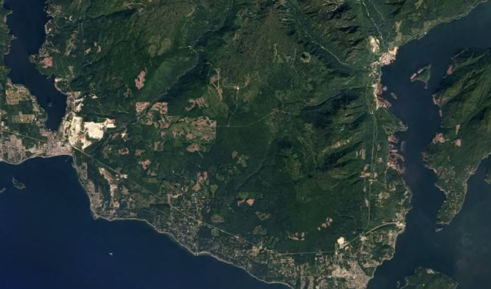
Click on Link to View Time Lapse Forest Cut Block Images

Aerial Maps – Time-lapse map over the lower Sunshine Coast -quite dramatic showing the changes


Elphinstone Logging Focus
PO Box 85
Roberts Creek, B.C. V0N 2W0

604-740-5654
loggingfocus@gmail.com

  • Facebook

Hestia | Developed by ThemeIsle